Still watching.
Scant chance (<30%) of development over then next 7 days with no chance of development in the next 48 hours.
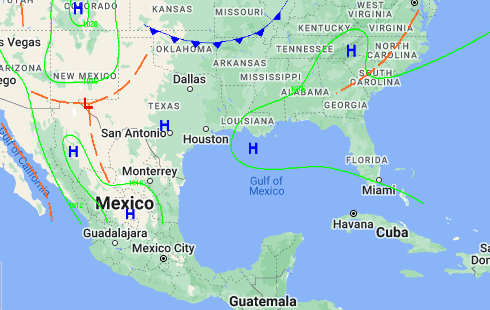
There are models available that suggest later in the forecast it turns to the north and scrapes the east-coast of Florida. Others say it comes in the Gulf of Mexico. I say it way too early to tell.
I’m not at the “Concerned” level as of yet. But, I am increasing my awareness to monitor the disturbance daily.
Below are several bits of raw, unexpurgated data used to fuel my thought. I hope it fuels yours. –Jazzy J
Frontal systems in 7 days seem to show the Gulf of Mexico to be dominated by high pressure systems making it difficult for storm development.
From the NHC
Tropical Weather Outlook
ZCZC MIATWOAT ALL
TTAA00 KNHC DDHHMM
Tropical Weather Outlook
NWS National Hurricane Center Miami FL
800 AM EDT Sat Jul 27 2024
For the North Atlantic…Caribbean Sea and the Gulf of Mexico:
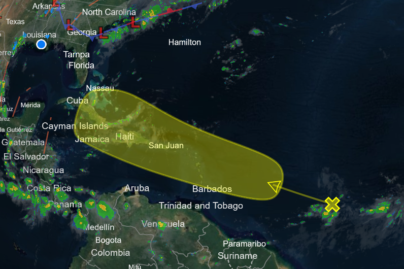
1. Near the Lesser and Greater Antilles:
An area of disturbed weather over the central tropical Atlantic
Ocean is expected to interact with an approaching tropical wave
during the next several days. Development of this system is possible while it approaches the Lesser Antilles during the early to middle part of next week and moves generally west-northwestward near or over the Greater Antilles towards the latter part of next week.
* Formation chance through 48 hours…low…near 0 percent.
* Formation chance through 7 days…low…30 percent.
Forecaster Berg
Atlantic Tropical Weather Discussion
000
AXNT20 KNHC 270919
TWDAT
Tropical Weather Discussion
NWS National Hurricane Center Miami FL
1205 UTC Sat Jul 27 2024
Tropical Weather Discussion for North America, Central America
Gulf of Mexico, Caribbean Sea, northern sections of South
America, and Atlantic Ocean to the African coast from the
Equator to 31N. The following information is based on satellite
imagery, weather observations, radar and meteorological analysis.
Based on 0600 UTC surface analysis and satellite imagery through
0900 UTC.
…TROPICAL WAVES…
An eastern Atlantic tropical wave has its axis along 26W, south
of 22N, moving westward at 15-20 kt. Scattered moderate convection is observed from 12N to 15N and between 24W and 27W.
Another eastern Atlantic tropical wave has its axis along 37W, south of 22N, moving westward at 10 kt. No significant convection is evident near this tropical wave.
A western Caribbean tropical wave has its axis along 84W, south
of 19N, moving westward at 20-25 kt. A few showers thunderstorms are evident near the trough axis over eastern Honduras and Nicaragua.
…MONSOON TROUGH/ITCZ…
The monsoon trough enters the Atlantic through the coast of
Mauritania near 18N16W and continues southwestward to 06N55W. Scattered moderate convection is present from 09N to 12N and between 15W and 20W.
GULF OF MEXICO…
A weak surface trough in the western Gulf and divergence aloft
continues to generate a few showers and isolated thunderstorms in the vicinity of the trough and the northern Gulf waters. The Gulf of Mexico is under the influence of a broad subtropical ridge over the central Atlantic that extends westward into the basin. A
recent scatterometer satellite pass indicated moderate to fresh NE winds off the western coast of the Yucatan Peninsula. Seas in these waters are 2-3 ft. Elsewhere, light to gentle winds and
slight seas are prevalent.
For the forecast, a ridge will remain in place across the Gulf
waters through Wed allowing for gentle to moderate winds and
slight to moderate seas. Winds will freshen up at night off NW
Yucatan over the next several days.
CARIBBEAN SEA…
A broad upper level trough centered near the central Bahamas
induces scattered showers in the north-central Caribbean,
from eastern Cuba to Grand Cayman. An earlier scatterometer
satellite pass indicate that winds to near gale-force are
occurring in association with the strongest convection. The basin
is dominated by a broad subtropical ridge positioned north of the
islands. This ridge forces fresh to strong easterly trade winds
over much of the central and SW Caribbean. Seas in these waters are 6-9 ft, as shown by recent altimeter satellite data. Moderate to locally fresh easterly breezes and seas of 5-7 ft are found in the eastern Caribbean, Gulf of Honduras and lee of Cuba. Light to gentle winds and slight to moderate seas prevail elsewhere.
For the forecast, a tropical wave will move westward across the
northwest Caribbean today. The Atlantic ridge is building over
the eastern and central Caribbean in the wake of the wave. This
pattern will support fresh to strong trade winds and rough seas
across the central Caribbean into the middle of the week. Expect
moderate to fresh E to SE winds and building seas over the
northwest Caribbean behind the wave axis through Sun with
locally strong winds and rough seas across the Gulf of Honduras
Sun night.
ATLANTIC OCEAN…
A broad upper level trough from 30N55W to the central Bahamas
continues to produce scattered showers and a few thunderstorms from the central Bahamas to central Cuba, and north of 27N between 55W and 60W. The Atlantic south of 30N is under the influence of an expansive subtropical ridge positioned over the central Atlantic. Fresh easterly winds are found off northern Hispaniola, along with seas of 4-6 ft. In the far northeast Atlantic, fresh tolocally strong northerly winds are occurring north of 25N and east of 20W, with the strongest winds affecting the water passages of the Canary Islands. Seas in these waters are 5-8 ft. Elsewhere, moderate or weaker winds and slight to moderate seas are prevalent.
For the forecast west of 55W, the Bermuda-Azores high will
dominate the Atlantic forecast waters through the next several
days. It will shift eastward ahead of a weak cold front moving off the Carolina coast today. The front will stall then dissipate
between northeast Florida and Bermuda Sun into Mon. The pattern will support fresh south of 22N, and gentle to moderate breezes elsewhere into mid week. Looking ahead, winds and seas may increase northeast of the Leeward Islands by late Tue associated with an approaching tropical wave.
$$
Christensen
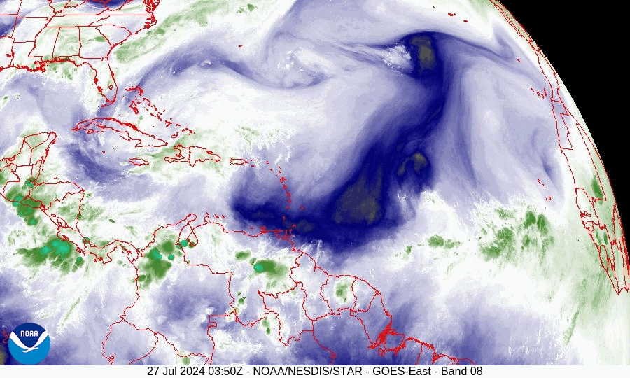
Satellite sequence July 27, 2024 showing the tropical waves crossing the Atlantic from the African coast.