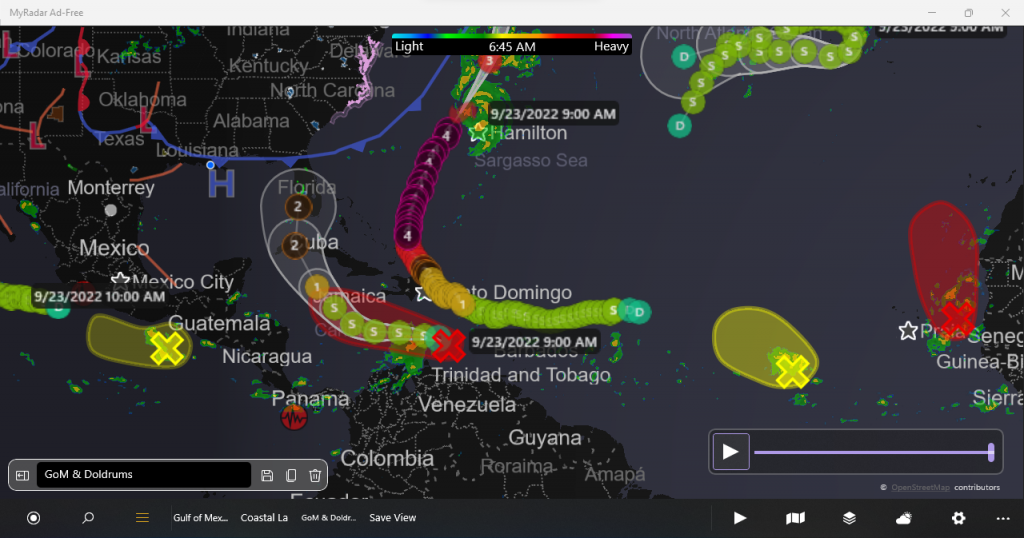
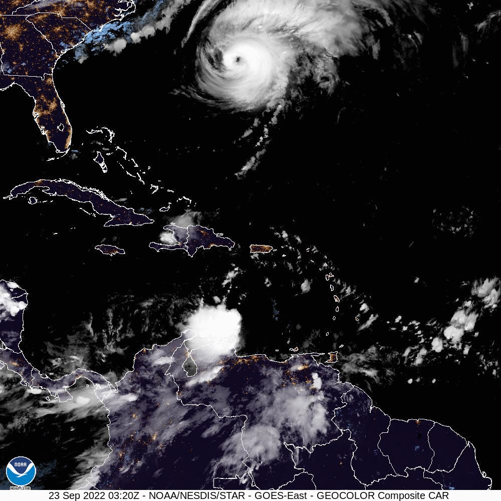
Very active Atlantic and Caribbean. Thankfully, the Gulf of Mexico is silent now. Next week we may see South to Central Florida get attacked by a Category 2 Hurricane.


| Tropical Weather Outlook Text |
ZCZC MIATWOAT ALL
TTAA00 KNHC DDHHMM

Tropical Weather Outlook
NWS National Hurricane Center Miami FL
800 AM EDT Fri Sep 23 2022

For the North Atlantic...Caribbean Sea and the Gulf of Mexico:

Active Systems:
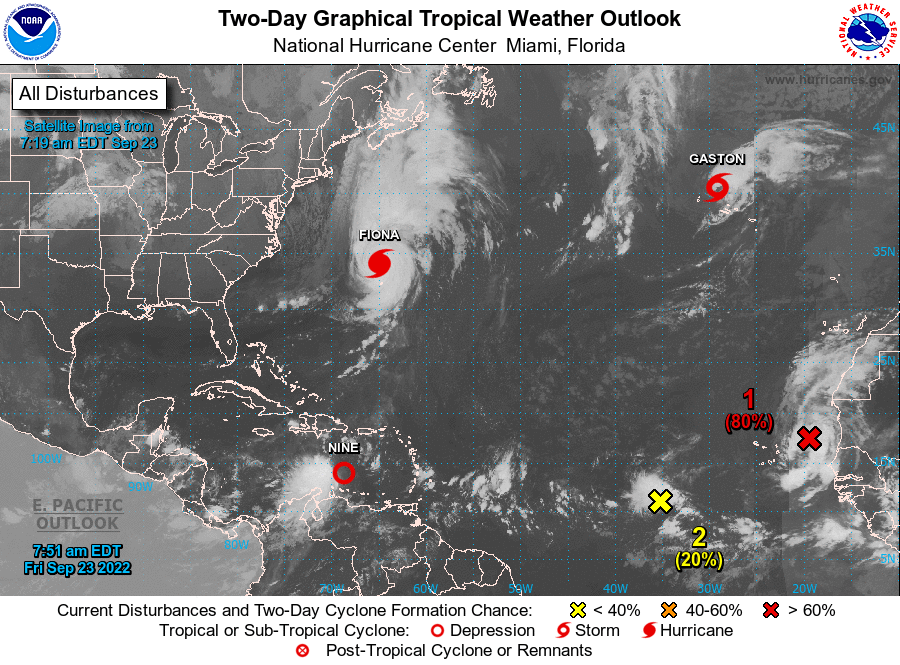
The National Hurricane Center is issuing advisories on Hurricane
Fiona, located north of Bermuda, on Tropical Storm Gaston, located
near the central Azores, and on newly formed Tropical Depression
Nine, located several hundred miles east-southeast of Jamaica over
the eastern Caribbean Sea.

1. Eastern Tropical Atlantic:
Shower and thunderstorm activity associated with an area of low
pressure located between the Cabo Verde Islands and the west coast
of Africa is showing increased signs of organization. Environmental
conditions are forecast to be generally conducive for further
development during the next day or so, and a tropical depression is
likely to form while the system moves northward at about 10 mph,
roughly parallel to the coast of west Africa.
* Formation chance through 48 hours...high...80 percent.
* Formation chance through 5 days...high...80 percent.

2. Central Tropical Atlantic:
A broad area of low pressure located several hundred miles
west-southwest of the Cabo Verde Islands continues to produce some
disorganized shower and thunderstorm activity. Despite marginal
environmental conditions, some slow development of this system is
possible over the next several days while it drifts northwestward or
northward over the central tropical Atlantic.
* Formation chance through 48 hours...low...20 percent.
* Formation chance through 5 days...low...30 percent.

Public Advisories on Tropical Depression Nine are issued under WMO
header WTNT34 KNHC and under AWIPS header MIATCPAT4.
Forecast/Advisories on Tropical Depression Nine are issued under WMO
header WTNT24 KNHC and under AWIPS header MIATCMAT4.

Forecaster Reinhart
000
AXNT20 KNHC 231043
TWDAT

Tropical Weather Discussion
NWS National Hurricane Center Miami FL
1205 UTC Fri Sep 23 2022

Tropical Weather Discussion for North America, Central America
Gulf of Mexico, Caribbean Sea, northern sections of South
America, and Atlantic Ocean to the African coast from the
Equator to 31N. The following information is based on satellite
imagery, weather observations, radar and meteorological analysis.

Based on 0600 UTC surface analysis and satellite imagery through
1000 UTC.

...SPECIAL FEATURES...

Major Hurricane Hurricane Fiona is centered near 33.8N 66.8W at
23/0900 UTC or 130 nm NW of Bermuda moving NNE at 22 kt. Estimated
minimum central pressure is 936 mb. Maximum sustained wind speed
is 110 kt with gusts to 135 kt. Numerous strong convection is
within 300 nm NE quadrant, 240 nm SE quadrant, and 150 nm W
semicircle. Seas of 12 ft or higher are occurring within 390 nm
all quadrants, except 250 nm NE quadrant with peak seas near 50
ft. Fiona passed just W of Bermuda early this morning and will
continue moving away from the island today. A Hurricane Warning
remains in effect for Bermuda. On the forecast track, the center
of Fiona will approach eastern Nova Scotia tonight, and a
Hurricane Warning is also in effect for Nova Scotia and adjacent
portions of Atlantic Canada. Swells generated by Fiona are
affecting the Turks and Caicos Islands, the Bahamas, the
southeastern United States coast, and Bermuda. These swells will
continue to spread northwestward across the western Atlantic
toward the mid- Atlantic and northeast coasts of the United States
and Atlantic Canada today. These swells are likely to cause life-
threatening surf and rip current conditions. Please read the
latest High Seas Forecast issued by the Ocean Prediction Center at
website https://ocean.weather.gov/shtml/NFDHSFAT1.php and the
latest NHC Forecast/Advisory and Public Advisory at
www.hurricanes.gov for more details.

Tropical Storm Gaston is centered near 40.5N 29.6W at 23/0900
UTC or 120 nm NNW of Faial Island In The Central Azores moving
ESE at 8 kt. Estimated minimum central pressure is 999 mb.
Maximum sustained wind speed is 50 kt with gusts to 60 kt.
Numerous moderate to scattered strong convection is noted within
210 nm of the center in the NE quadrant, 150 nm SE quadrant and
120 nm NW quadrant. A Tropical Storm Warning is in effect for the
Azores, where the forecast track keeps the center of Gaston in the
vicinity through Saturday. In addition to gusty winds, heavy rain
and swells will impact portions of the Azores into the weekend.
The swells are likely to cause life- threatening surf and rip
current conditions. Please read the latest High Seas Forecast
issued by the Ocean Prediction Center at website
https://ocean.weather.gov/shtml/NFDHSFAT1.php and the latest NHC
Forecast/Advisory and Public Advisory at www.hurricanes.gov for
more details.

Newly-formed Tropical Depression Nine is centered near 13.9N
68.6W at 23/0900 UTC or 530 nm ESE of Kingston Jamaica moving WNW
at 11 kt. Estimated minimum central pressure is 1006 mb. Maximum
sustained wind speed is 30 kt with gusts to 40 kt. Numerous strong
convection is noted from 11N to 14N between 68W and 72W. Tropical
Depression Nine is expected to produce heavy rainfall and flash
flooding along with possible mudslides of higher terrain in Aruba,
Bonaire, and Curacao into tonight. Heavy rain will likely spread
into Jamaica and the Cayman Islands into the weekend.
Strengthening is forecast, and the depression is likely to become
a tropical storm later today. Interests in Cuba should closely
monitor this depression. Please read the latest NHC Public
Advisory at https://www.nhc.noaa.gov/text/MIATCPAT4.shtml and
Forecast/ Advisory at
https://www.nhc.noaa.gov/text/MIATCMAT4.shtml for more details.

Eastern Atlantic Low Pressure: A 1005 mb low pressure center near
17N20W, associated with a tropical wave along 20W is moving WNW at
5 to 10 kt. Numerous moderate to scattered strong convection is
noted with this low from 13N to 20N between 17W and 22W. This
convection has become better organized early this morning, despite
the overall circulation of the low being quite broad.
Environmental conditions are generally favorable for development
over the next day or so, and a tropical depression is likely to
form by this weekend as the low turns more NW to NNW at 5 to 10
kt, parallel to the coast of Africa and E of the Cabo Verde
Islands. There is a high chance of tropical cyclone formation
within the next 48 hours.

...TROPICAL WAVES...

Please read the Special Features section above for information
about the tropical wave associated with low pressure in the far
eastern Atlantic.

...MONSOON TROUGH/ITCZ...

The monsoon trough passes off the west coast of southern
Mauritania near 17N16W to a 1005 mb low pressure near 17N20W to a
1009 nm low pressure near 11N35W. The ITCZ then extends from
12N37W to 07N48W to 08N60W. Aside from convection associated with
the 1006 mb low described in the Special Features section above.
numerous moderate to isolated strong convection is noted from 07N
to 13N between 30W and 37W. Scattered moderate convection is
noted from 06N to 09N between 24W and 30W and from 10N to 16N
between 49W and 60W.

GULF OF MEXICO...

A 1014 mb surface high pressure is centered just offshore of SE
Louisiana near 29N89W. This is bringing benign weather, with
gentle to moderate winds across the basin. Seas of 1-3 ft prevail.

For the forecast, newly-formed Tropical Depression Nine, located
early this morning in the SE Caribbean Sea, is forecast to
strengthen into a hurricane as it moves NW toward the NW Caribbean
into the weekend. By the start of next weeks, impacts from this
system may begin to affect portions of the SE Gulf of Mexico, in
the form of increasing wind and seas. Otherwise, a relatively weak
pressure gradient across the Gulf waters will support mainly
gentle to locally moderate winds and slight seas through the
weekend.

CARIBBEAN SEA...

Please read the Special Features section above for details about
nearly formed Tropical Depression Nine.

The east Pacific monsoon trough is inducing scattered moderate
convection S of 17N, mainly within about 90 nm of the Central
American coast. Light to gentle winds prevail across the western
and central Caribbean, west of 72W. Seas in this area are 1-2 ft.
Fresh to near-gale force winds and seas of 5-10 ft prevail over
the eastern Caribbean in association with the tropical depression.

For the forecast, Tropical Depression Nine has formed early this
morning near 13.9N 68.6W 1006 mb at 5 AM EDT moving WNW at 11 kt.
Maximum sustained winds are 30 kt with gusts 40 kt. Nine will
strengthen to a tropical storm near 14.4N 70.2W this afternoon and
move to 14.7N 72.6W Sat morning. Nine will be at 14.8N 75.0W Sat
afternoon, 15.5N 77.1W Sun morning, and 17.0N 78.8W Sun afternoon.
Nine will strengthen to a hurricane near 18.9N 80.5W Mon morning
and change little in intensity as it moves north of the Cayman
Islands early Tue. Deteriorating marine conditions can be expected
near the track of Nine, including the central Caribbean today and
Saturday, and portions of the northwest Caribbean Sunday and
Monday. Locally heavy rainfall and gusty winds will impact Curacao
and Aruba today and Jamaica this weekend. Interests in the Cayman
Islands should closely monitor the progress of Nine.

ATLANTIC OCEAN...

See Special Features section above for information on Hurricane
Fiona, Tropical Storm Gaston, and low pressure east of the Cabo
Verde Islands likely to become a tropical depression in the next
48 hours.

Away from these special features, surface ridging prevails across
most of the basin, north of 20N and east of 60W, anchored by a
1024 mb high pressure near 33N38W. Mostly moderate winds and 4-6
ft seas prevail across the central Atlantic between 40W-60W. Over
the E Atlantic, winds are fresh with 5-7 ft seas. A line of
thunderstorms about 30 nm wide extends from 25N67W to 27.5N65W.

Disorganized convection associated with broad 1009 mb low pressure
centered near 12N36W is occurring in an environment marginally
favorable for tropical development. Thus, some slow development is
possible with this low over the next several days as it drifts NW
or N over the central Tropical Atlantic. There is a low chance of
tropical formation over the next 5 days.

For the forecast west of 55W, Major Hurricane Fiona is beginning
to move N of the area early this morning, and is near 33.8N 66.8W
936 mb at 5 AM EDT moving NNE at 22 kt. Maximum sustained winds
110 kt gusts 135 kt. Category 3 Fiona will move to 37.9N 63.9W
this afternoon, 43.2N 62.0W Sat morning, then become extratropical
and move to 47.0N 61.1W Sat afternoon. Fiona will weaken as an
extratropical cyclone near 50.1N 59.7W Sun morning, 53.8N 58.4W
Sun afternoon, and 57.5N 58.3W Mon morning. Fiona will change
little in intensity as it moves through the Labrador Sea early
Tue. Swells generated by Fiona will continue to spread
northwestward across the western Atlantic toward the mid-Atlantic
and northeast coasts of the United States over the next day or so.
The swells will also reach Atlantic Canada on Friday. These
swells are likely to cause life- threatening surf and rip current
conditions. Impacts from newly formed Tropical Depression Nine,
currently in the SE Caribbean Sea, may affect areas offshore
Florida early next week.

$$
KONARIK
Leave a Reply