Skip to content
Weather.JayCTheriot.Com

Weather.JayCTheriot.Com

Be Wise. Be Safe. Be Informed

  • Home
    • Purpose and Scope
    • Glossary
    • Coastal Weather Anomaly Advance Detection System (CWAADS)
      • Multi-dimensional reduction of systemic error in data analysis specific to coastal weather anomalies as data from buoys dictate
      • Coastal Weather Anomaly Advance Detection System (CWAADS)
      • GoM Buoy Data Feeds
      • ToDo
  • Theaters
    • NHC Gulf of Mexico Information
    • Atlantic
    • NOAA Gulf of Mexico Imagery
    • Atlantic Watch
    • Central Pacific
    • Eastern Pacific
    • Caribbean
    • Atlantic
  • Gulf of Mexico
    • Northern Gulf Coast Current Conditions
    • SELA Current Info
    • Global Buoys and Storm Overlays
    • Gulf of Mexico
    • Gulf of Mexico and US Mainland Conditions
  • Blog
  • Toggle search form

Tag: atlantic

September 27, 2022 – Ian Interim update

Posted on September 27, 2022September 27, 2022 By Jazzy J No Comments on September 27, 2022 – Ian Interim update
September 27, 2022 – Ian Interim update

Almost 16ft. waves detected off the west coast of the keys by Buoy Station42095 – Satan Shoal, FL . See graphic below.

https://www.ndbc.noaa.gov/station_page.php?station=42095

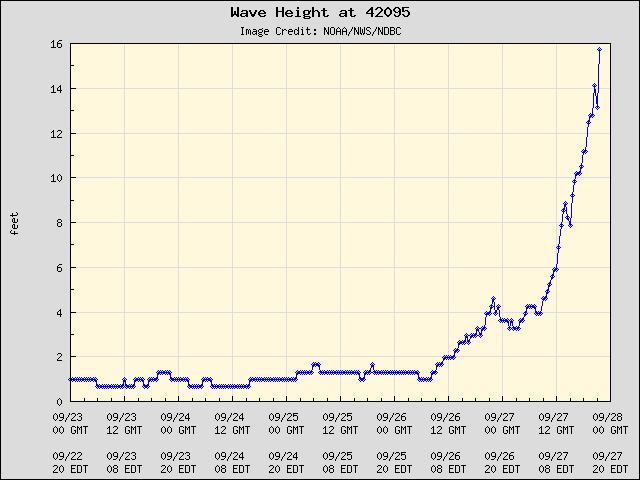
Nearly 16 ft. Waveheights at Satan’s Shoal, FL, WSW of the Keys.

6:25 EST, 27 Sep 22, Hurrican Ian, Radar and Projections

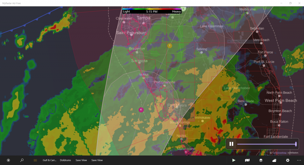
Due to the geographic shape of Charlotte Harbor, direction and size of the tidal surge, and the location of Port Charlotte and to a lesser extent Punta Gorda, massive inundation of those urbanized areas by a potentially deadly surge in excess of 20 ft. is possible. I cannot urge the people of those areas to evacuate strong enough. This mathematician and big-data-set junkie doesn’t not like what he sees.

The Harbor does have barrier islands protecting them. This will be considerably effective in under-capping the strength of the tidal surge. However, with the the geographic shape of the Harbor and the placement of Port Charlotte at the end of the funnel like the corner pocket of a pool table, much acceleration and concentration of the tidal force is likely to be directed bluntly at Port Charlotte.

The current winds are considerable. Category 4 at landfall is forecast by NOAA’s NHC, rapidly diminishing into a Category 1.

If you can evacuate, do.

Jay C. “Jazzy J” Theriot

  • No current storm in NHC Atlantic Wallet 4
    September 29, 2023
    No current storm in NHC AT4 as of Fri, 29 Sep 2023 15:45:01 GMT
A 2022, Ian, Uncategorized

Posts navigation

Previous 1 2 3 4 … 8 Next

Copyright © 2007-2023 Jay C. Theriot, all rights reserved.

Powered by Pressbook modified for Weather.JayCTheriot.Com WordPress theme